International-European PlugIn Exercise 2022 INT-EU PIX 22

Project’s name:

International-European PlugIn Exercise 2022

Project start:

01.03.2022

Project duration:

24 Months
(in case of COVID-19 related delays – 36 Months)

the Project Coordinator:

the European University of Cyprus (EUC/CYP)

the Project Partners:

  1. Norwegian Directorate of Civil Protection (DSB/NOR),
  2. Resilience Solutions International (RSI/AUT),
  3. Prepared International UG (PPI/GER)
  4. D.M.A.T. Consulting KG (DMAT/AUT).

The Project tasks:

The task of the consortium is to implement a UCPM (EU Civil Protection Mechanism) support module in a planned large-scale exercise for disaster management.
In this project, a 3-day (24/7) plug-in exercise (PIX) is designed, planned, implemented and evaluated outside of Europe in a country with different emergency management structures (e.g. other structures, response mechanisms, culture and climate conditions).

Based on the European Commission’s final decision, the PIX will take place either in South Asia/Nepal involving Asian Disaster Preparedness Center/ADPC, or West Africa/Ghana or Cabo Verde involving Economic Community of West African States / ECOWAS, or East Africa /Djibouti involving Intergovernmental Authority on Development / IGAD.

The background of the plug-in exercise:

The UCPM is often activated for dealing with emergencies outside the European Union. Most of the UCPM exercises conducted to reflect this often use fictitious scenarios and artificial countries to simulate the response environment. Although these exercises are needed, they do not necessarily provide the true nature of real deployments. At the same time, disaster management exercises outside Europe take place worldwide every year. This could allow for opportunities to join, i.e. plug-in to, planned large-scale exercises involving a multi-organisation response by providing an EUCPT, modules and/or other response capacities.

The overall objective of the Mechanism is to strengthen the cooperation among Member States in the field of civil protection for preventing, preparing for and responding to natural and man-made disasters. Any country in the world overwhelmed by a disaster can call on the Mechanism for support. By pooling the civil protection capabilities of the Member States, the Mechanism can ensure better protection primarily of people, but also of the natural and cultural environment and of property.

The Emergency Response Coordination Centre (ERCC) is the operational heart of the Mechanism. It is operated by DG ECHO and is operational 24 hours a day and 7 days a week.

The project objectives:

  1. test and improve the coordination of the UCPM response assistance, and ultimately to establish a common understanding in major emergencies.
  2. improve interoperability, coordination, communication, reporting and logistical arrangements in civil protection assistance with the different response capacities, national authorities, local emergency management authorities, humanitarian actors and other agencies with a role in emergency response.
  3. improve the field cooperation between EUCPT and UNDAC.
  4. enhance the cooperation with the EU Delegation(s), DG ECHO Field Office and EU Member States embassies in the region or country affected.
  5. develop and implement a safety and security plan for an emergency response outside EU.
  6. strengthen the understanding of Host Nation Support and introduce the EU HNS guidelines

PDEX-JIP (UCPM-2021-EX)

Project’s Titel:

Professional Dialogue Exercises – Jordan Israel Palestine

Project start:

15.11.2021

Project duration:

18 months

Coordinator:

European University Cyprus (EUC)

Project’s Partners

  1. D.M.A.T. Consulting KG (DMAT)
  2. Prepared International (PPI)
  3. Resilience Solutions International (RSI)
  4. Johanniter-Unfall-Hilfe e.V. (JUH)
  5. Ministry of Interior Cyprus (CCD)
  6. Ministry of Foreign Affairs Cyprus (MFA)

Project’s background

The project team for this exercise was requested by the three parties: Jordan, Israel, and Palestine (JIP). Parts of the team have a long-standing background with the Professional Dialogue project.

Mr. Beck was the founder and long-term project manager and mediator of the Professional Dialogue and, currently acting as a reference person for the countries. Mr. Hirschmugl & Mr. Beck were also involved in the UNDAC Disaster Response Preparedness mission to Palestine in 2014. This exercise project has been prepared from the JIP meeting 2019 in Austria onwards where DMAT Consulting KG (DMAT) and Prepared International (PPI) presented the lessons from all previous exercises that have taken place in the region.

The Jordanian, Israeli, and Palestinian emergency management frameworks provide a unique environment for disaster preparedness work. The range of risks and vulnerabilities coupled with the existing framework for response have the potential to cause the entire region to suffer severe impacts in case of a major disaster, such as a strong earthquake.

The project is designed to achieve overall strengthening of disaster preparedness in the JIP region while increasing interoperability and HNS measures for international and regional disaster response.

Aim of the Project

to improve civil protection (CP) preparedness and response inside and outside the Member States of the Mechanism by providing a testing environment and a learning opportunity for all actors involved in CP interventions.

The consortium will:

  1. produce an assessment of the CP situation,
  2. draft joint Standing Operating Procedures on parties’ request (SOPs),
  3. hold joint planning conferences,
  4. implement a Table-Top Exercise (TTX) training Host Nation Support (HNS) in a specific environment,
  5. perform a Joint Full-Scale Exercise (FSX),
  6. provide an Evaluation that includes a Lessons Learned (LL) process and recommendations for the Way ahead,
  7. provide the sub-region with HNS-guidelines considering the specific response environment.

Project’s Objectives:

  1. analyse the CP situation in the JIP region,
  2. conduct joint planning with JIP partners,
  3. develop a joint SOP for international disaster response,
  4. prepare and conduct one HNS TTX,
  5. prepare and conduct one joint FSX,
  6. conduct an evaluation of the current situation in the region
  7. conclude with a LL procedure and recommend a way ahead for the JIP region


The Project’s Exercises:

PDEX-JIP – Tabletop Exercise (TTX)

The aim of the TTX is to conduct a discussion-based exercise, in which the planned FSX scenario will be simulated and discussed. All relevant existing plans, documents, maps, guidelines etc. can be used and discussed, possible problems and connected solutions identified and at the end the ground for an efficient simulated FSX should be set.

Objectives of this exercise:

  1. Discuss the possible FSX scenario – Earthquake and cascading effects, including outbreak of a pandemic and lock down during the exercise
  2. Discuss the activation of the EUCPM (Alert, requesting and offering relief teams and relief goods)
  3. Discuss EU HNS Guidelines – procedures of sending states, transiting states and hosting/receiving states – what changes in a pandemic environment – for the guidelines. Discuss and confirm the SOPs developed by the project.
  4. Discuss cooperation with Local Emergency Management Agency/LEMA, EU Delegation on site, UN OCHA ERCC and EU ERCC, UN Resident Coordinator, UNDAC, etc.
  5. Discuss involvement and cooperation of UNHAS/WFP,
  6. Discuss activation and support by Copernicus and UNITAR/UNOSAT
  7. Strategize on supporting most vulnerable groups
  8. Identification of cascading effects and particularities in urban areas
  9. Discuss involvement of modules, ECPP and RescEU in such a disaster
  10. Discuss an exit strategy and hand over / Take over procedures for mission end
  11. Discuss trilateral cooperation of JIP


Joint Full-Scale Exercise (FSX)

Aim of this exercise: to conduct an operations-based exercise with deployment and field response to JIP as the affected countries. The scenario is the further developed TTX scenario with all recommendations included. All existing procedures due to a real mission situation will be tested in the field with involvement of a variety of organisations and agencies which one will meet in the field. All real mission activities of UCP will be included in a 12 hrs -per day exercise (minimum 36 hours’ total time) under stressful conditions and time pressure.

Objectives of this exercise:

  1. Exercise a possible FSX scenario – Earthquake and cascading effects, including outbreak of a pandemic and lock down in the field and test specific SOPs for support between JIP entities, specific focus on most vulnerable groups
  2. Activate the EUCPM (Alert, requesting and offering relief teams and relief goods) and deploy an EUCPT on site
  3. Deploy teams from the neighbourhood to support in the first hours after the event
  4. Deploy an EUCPT, TAST, EU modules, teams from ECCP or RescEU (3-4 Skeleton teams or other capacities) to JIP
  5. Test all relevant procedures like the EU HNS Guidelines – information sharing procedures, procedures for assessments and coordination, meetings, incoming relief goods etc.
  6. Experience the cooperation with LEMA, EU Delegation on site, UN OCHA ERCC and EU ERCC, UN Resident Coordinator, UNDAC, etc. in real
  7. Involve other relevant organisations like UNHAS/WFP,
  8. Experience activation and support by Copernicus and UNITAR/UNOSAT
  9. Prepare an exit strategy and hand over / Take over procedures for mission end
  10. Experience trilateral cooperation of JIP

B-Sure Benefiting from Space for Urban Resilience Excellence

Project’s Partners

  1. AnsuR (Norway)
  2. Johanniter (Germany)
  3. iGeotec (Ireland)
  4. DroneSAR (Ireland)
  5. UNITAR (Geneva)

Background

Based on a current platform called ASIGN, listed as one of United Nations Information Management tools for disasters, and in use by Oslo Police for security, B-SURE will develop user-driven functional capabilities and technical solutions for providing commercial services for target markets.
The B-SURE project is supported by the UN, who will be acting as a developing partner, reference user and possible future client.


B-Sure Logo

What is B-Sure

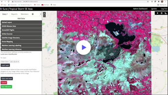
B-SURE is about creating urban resilience by providing novel situational awareness capabilities for faster and better response in in critical situations related to disaster management and security.

By fusing information from space spaced EO observations, Unmanned vehicles (drones) and geospatial images from the ground communicated from smartphones, via satellite communications if needed, B-SURE creates a portal providing unique common operational picture for United Nations and other professional disaster management organizations.

Objective

to reduce disaster management response time

B-SURE Services

The main B-SURE service is rapid collection and bandwidth efficient secure communication of operationally relevant field information. The baseline field platform is a smartphone, while information managers access data and interact with the field users via Web browsers online on secure servers. The field users cover professionals, civil population and small UAV operators.

The B-SURE service forms a unique basis for a rapidly updated visual situational awareness service with photos and video and associated data sources. While user needs are clearly present, a large commercial market can be challenging to acquire. Therefore, suitably flexible service and delivery models will be developed, supporting both partner and direct sales.

B-SURE will provide an innovative solution based of photos/images and video collected from the field to:

  1. Improve visual situational awareness (e.g. damage and needs assessment after an Earthquake), via better collection and communication of relevant photos and video content from the field (i.e. non-essential data need not be sent).
  2. Improve the relevance and effect of collected data, as the bandwidth savings also saves time to transfer data, making it much more efficient to interact with the field observers or drone pilots while data capture is done.
  3. Improve training of professional in the field (this includes pilots of UAVs) about how to best acquire useful photo/videos in the field. This is usually done prior to a crisis
  4. Support remote pilots of UAVs to be more effective to collect useful photos and videos. This is typically done real-time during the critical operations
  5. Embed the useful data from Videos/Photos and Earth Observation in overlaying pictures/maps generated as well with the support of EO data
  6. Finally, provide access to the visual situational awareness tool via a web-based service accessible to users via smartphones and PCs connected to Internet.

HOW does B-Sure work

Merging experience and expertise both from software developers and professional disaster managers, B-SURE utilizes a concept using interactive communication, where a smaller image or video storyboard is sent initially, allowing the receive side to pull the required details in full precision. The savings imply 1% of the cost and 100 times increase in speed. This capability is a unique core element for the B-SURE geo-spatial visual situational awareness that is combined with rapid mapping from latest satellite EO data. We apply Computer Vision and Machine Learning to complement and assist the analysts and decision makers.

The project has also developed mission critical video conferencing that can support users joining from the field with low bandwidth, even using mobile satellite communications. the video conferences combined with live drone video feeds, photo communications and live mapping.


B-SURE product videos : link

ASIGN

DroneSAR

iGEOTEC


For more detailed information please visit the following websites:

Project’s webpage: link